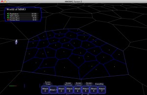
 I’ve been playing around with terrain authoring systems lately. The current one I’m experimenting with is kind of a tile system, with non-regular tiles.
In this screenshot, you’re looking at a portion of a region map; the dull grey lines show region borders. Inside the (unusually large) region in the middle of the screen, the blue borders show what I’m currently calling “districts” of a region. I’m thinking about letting the player set each district as “grassland” or “forest” or “mountain” or etc., and having those choices drive the generation of the overall region terrain.
Not sure whether I’ll go with this approach in the end, but I do like it more than asking players to directly paint on the heightmap, and then having every save games be several hundred megabytes in size due to having to save the resulting MMO terrain as an extremely high-resolution image. :)


